
Filter by:
News
Stay informed of all the latest Deltares developments in the field of water and subsurface.
-
Fresh groundwater under the sea: a potential source of water?
There are large volumes of fresh groundwater below the seafloor in many coastal areas around the world. They could perhaps be used as a temporary source of water in water-stressed coastal regions. 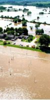
High water in Limburg in the summer of 2021 had more impact than river floods in 1993 and 1995
The intense rainfall and high water of July 2021 in the Netherlands and the neighbouring countries was an extreme and exceptional event with a major social impact in Limburg. On behalf of the Expertise Network on Flood Risk Management (ENW), a broad consortium of research institutions led by Delft University of Technology and Deltares has now completed an initial analysis of the available information on a range of subjects.
Nature-based Solutions as cost-effective method to drive climate change adaptation
With Germany, Belgium and Turkey still reeling from historic floods, a new report outlines how Nature-based Solutions can help reduce the impact of such disasters across Europe.-
50% of the Mekong Delta at risk of salinisation due to sand mining and dam building
Sediment starvation in the Mekong Delta can drive 50% of the area saline by 2050. This is shown in a study by the Rise and Fall Project of Utrecht University and Deltares, published in the Springer Nature journal Communications Earth and Environment. The researchers show that in the first half of the century, the anthropogenic forces, specifically eroding riverbeds due to sediment starvation, can have a 6-7 times larger impact on salt intrusion than climate change and sea level rise. -
Saint-Louis, caught between two threats
Deltares is working on two projects in Saint-Louis, Senegal, to protect the population against flooding from the Sénégal River and coastal erosion by the sea. “The problems are big, but we have collected a lot of data to arrive at the best solutions,” says Pieter Koen Tonnon, senior advisor at Deltares. Saint-Louis is caught between two threats. The coastal town in northern Senegal is located on a sand spit at the mouth of the Sénégal River, where high river levels cause flooding during the wet season. At the same time, the city borders on the sea, which means that storms and waves also cause flooding and coastal erosion on the narrow, vulnerable coast where many people live. -
New maps of foundation risk at neighbourhood level in the Climate Impact Atlas
Low groundwater levels caused by drought and land subsidence may result in damage to foundations. New maps in the Climate Impact Atlas now provide a clearer picture of the local risk of damage to wooden pile foundations (pile rot) and the differential settlement of buildings on steel foundations. -
Updated land subsidence maps show the effects of climate change and water level management
Nine million Dutch people live or work in areas where the land is subsiding. The extent of subsidence in the future depends mainly on the amount of gas and salt extraction, how much the climate warms up and on the water level policy in place. The new maps in the Climate Effect Atlas for forecasting land subsidence provide an insight into the extent of subsidence in the Netherlands until 2100. Water level policy - fixing the water level as opposed to indexing it - and climate change have been included in a high and a low scenario. 
Coastal retreat as a serious option to adapt to sea-level rise
Sea-level rise is expected to have severe consequences. To adapt to sea-level rise a range of options exists: protection, accommodation, coastal advance and retreat. So far, retreat has been mostly used post hoc, rather than preemptively. Researchers from Deltares, Utrecht University, New Zealand Climate Change Research Institute at Victoria University of Wellington, and Institute for Sustainable Development and International Relations demonstrate in the scientific journal Science how exploring pathways to managed retreat adds value in the context of the accelerating and long-term commitment to SLR. They argue that there is an urgent need to keep coastal retreat on the table as an option to adapt to sea-level rise.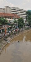
From source to sea transport and fate of plastic waste Indonesia
The World Bank has published Deltares-led study estimating plastic waste discharges from land-based sources in Indonesia. In this study, we provide the first Indonesia-wide assessment integrating local waste data with actual hydrological conditions to tell the story of how local waste handling practices contribute to marine plastic pollution.-
Global Water Watch: a platform to be developed by Deltares, WWF and WRI funded by Google
Societies and economies are under threat because of the unreliability of per capita water resources due to climate change, non-sustainable use and political instability. Worldwide water information is essential to address this fundamental challenge. To stimulate access to water information, the Dutch research institute Deltares has – with its partners World Resources Institute (WRI) and World Wide Fund (WWF) – received financial support from Google.org for the development of an app containing world-wide, high-resolution, near-real-time, water data. -
Global map shows nineteen percent of the global population may face a high probability of subsidence
A new global map shows that land subsidence as a result of the depletion of our groundwater resources is a global anthropogenic hazard that produces relevant environmental, social and economic impacts. According to the researchers which published the map in Science nineteen percent of the global population and twelve percent of the global gross domestic product may face a high probability of subsidence.


