
Global map shows nineteen percent of the global population may face a high probability of subsidence
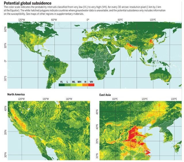
A new global map shows that land subsidence as a result of the depletion of our groundwater resources is a global anthropogenic hazard that produces relevant environmental, social and economic impacts. According to the researchers which published the map in Science nineteen percent of the global population and twelve percent of the global gross domestic product may face a high probability of subsidence.
Land subsidence is a slow and gradual geological hazard that usually affects soft sediments when e.g. groundwater is pumped from aquifers. It can permanently reduce the storage capacity of aquifer systems, damage buildings and infrastructures, and increase the flooding risk in alluvial areas and coastal plains. Even though subsidence phenomena have been studied for the past century worldwide, researchers have mostly focused on locally studying and solving the problem. This resulted in a list of case studies containing 200 locations in 34 countries that was used for this research. Based on these studies, the main environmental settings favoring land subsidence were identified and used to predict global subsidence susceptibility at a spatial resolution of 1 km2. This resulted in the presented global map of land subsidence susceptibility and potential.
Eighty six percent of the exposed global population lives in Asia
Potential subsidence areas threaten 1.2 billion inhabitants and 21% of the major cities worldwide, with 86% of the exposed population living in Asia. Even though further research is still needed to fully understand the global impact of land subsidence, this work estimates that the current economic exposure to potential subsidence amounts to US$8.17 trillion, or 12% of the global gross domestic product. Moreover, the research indicates that by 2040, an estimated 635 million inhabitants will be living in flood prone areas, where land subsidence could increase the flooding risk. “These numbers give a much needed first estimate of the global potential exposure to and damage from land subsidence” says Gilles Erkens, land subsidence expert at Deltares and Utrecht University. “This will help us identifying areas where land subsidence may occur but has so far not been recognized as such”.
Prevention or mitigation in the context of the global change
The research and the global map aim to raise global awareness and inform public authorities about this subsidence hazard. It can help to better understand subsidence phenomena, discover new subsiding areas and guide mitigation efforts. “Land planners, urban managers and water authorities could use this information to prevent or mitigate the impact of land subsidence, especially in the context of the global change” claims Dr. Herrera-García of IGME.
The article ‘Mapping the global threat of land subsidence‘ is published in Science on 1 January 2021.
