
New maps of foundation risk at neighbourhood level in the Climate Impact Atlas
Expert(s) |
Sien Kok
Low groundwater levels caused by drought and land subsidence may result in damage to foundations. New maps in the Climate Impact Atlas now provide a clearer picture of the local risk of damage to wooden pile foundations (pile rot) and the differential settlement of buildings on steel foundations.
The risk of damage depends on the exposure, the probability that a property in a local area has been built on susceptible foundations, and vulnerability, the probability that a property on susceptible foundations will actually suffer damage between now and 2050. The Climate Impact Atlas now includes three maps showing pile rot and the settlement of foundations on steel: exposure, vulnerability and the combination of the two, the risk. It is also possible to see how the risk varies depending on the level of climate change. Municipal authorities and property owners can draw on this information for an initial assessment of the foundation risk in their locality.
Problems with foundations in the Netherlands
Until the 1970s, the Netherlands used shallow steel foundations and wooden pile foundations in clay and peat soils. Those structures are susceptible to damage as a result of subsidence and low water tables: wooden piles can be damaged by fungi when oxygen gets to the wood. The processes involved are generally slow but damage can be faster if there is a sudden lowering of the water table or subsidence caused by building work. A drier climate can also trigger or accelerate foundation problems because of faster subsidence and lower water tables. The maps include the expected changes in groundwater levels in different climate scenarios.
Sien Kok, an economist with Deltares: “A nice next step would be the option of extending the analysis to include the shrinkage of clay layers during drought and the subsequent swelling when the ground gets wet again. We know that this also causes damage to buildings – it is actually the main cause in the UK and France – but not enough is known about the process in the Netherlands to include it in the calculations.” Ideally, other problems such as bacterial damage and the negative skin friction of wooden piles should also be included in the analyses.
Risk of damage
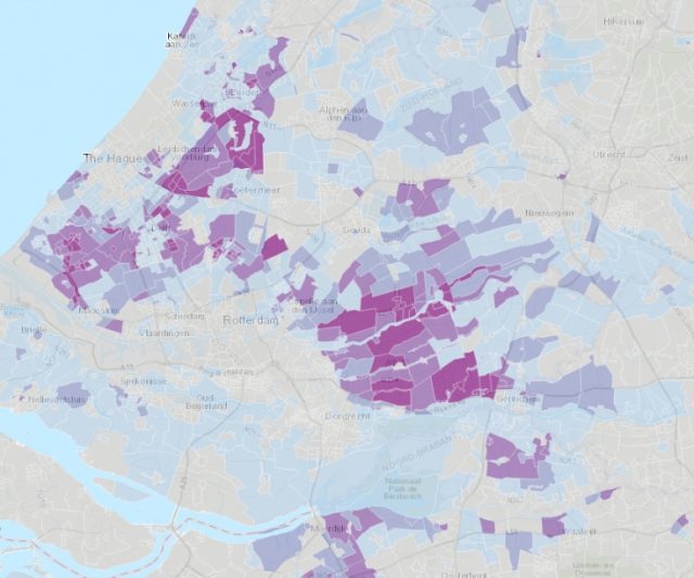
The risk of pile rot is particularly high in Zeeland, South Holland, the river area, northwest Friesland and the north of Groningen. The differential settlement of buildings on steel is seen mainly in North and South Holland, the river area, the centre and south of Friesland, Groningen, Drenthe, Brabant and northwest Overijssel. The difference between low and high levels of climate change is not very clear: it is apparent that there is a high risk of problems, even with the current climate. This is in line with the rise in damage reports in recent dry years. Some areas, such as Amsterdam, Rotterdam, Zaanstad, Dordrecht and Schiedam, have had foundation problems for decades.
What can the maps be used for?
The information in the Climate Impact Atlas is intended primarily to help municipal authorities to conduct climate stress tests as a basis for climate risk dialogues: the maps provide an initial indication of the order of magnitude of possible problems. Particularly in areas where climate change exacerbates the risk, climate adaptation measures may be able to prevent some of the damage. In terms of the approach to the problems with foundations in general, the maps are primarily intended to draw attention to the problem. Because national models and assumptions were used to create the maps and not all damage mechanisms have been included, they may not be complete or accurate locally. Where the map indicates a high risk in a particular area, that can serve as a good starting point for further investigation.
