Development of a water allocation model for major basins in Myanmar
The Netherlands Ministry of Infrastructure and Environment provides support to the Government of Myanmar in the development of an Integrated Water Resources Management Strategy for Myanmar, and has signed an MoU with the Myanmar Ministry of Transport, in name of the Myanmar National Water Resources Committee.

Deltares was commissioned to carry out an IWRM data inventory and analysis project that included:
- a concise overview of the status of water resources in Myanmar;
- a comprehensive overview of the availability of IWRM data and information;
- an inventory of promising IWRM measures for Myanmar;
- initial model developments to support the development of an Integrated Water Resources Management Strategy;
- recommendations for the development of a Water Knowledge Centre, to support and facilitate the development and implementation of an Integrated Water Resources Management Strategy.
In a follow-up strategy development project Deltares was commissioned with the further development of the rainfall-runoff model WFLOW and the RIBASIM water allocation model (ToR) for the major river basins in Myanmar.
To set up the WFLOW and RIBASIM models use has been made of global datasets to overcome the lack of reliable precipitation data. A validation was done by comparing two different global satellite reanalysis products with the available rainfall time series of several ground stations in Myanmar.
The global datasets that were assessed were TRMM (3B42) and WFDEI. TRMM (Tropical Rainfall Measuring Mission) is a satellite reanalysis product with a spatial resolution of 0.25*0.25°, mainly developed for low latitude regions. WFDEI (WATCH Forcing Data methodology applied to ERA-Interim data) is a combination of remote sensing and GPCC station data, and has a spatial resolution of 0.5*0.5°.
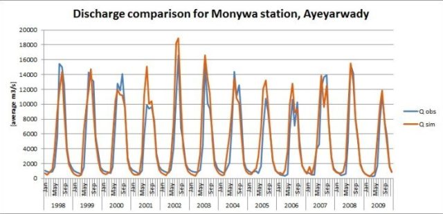
Despite the lack of hydro-meteorological data in Myanmar (such as spatial coverage and timeseries of precipitation stations and river discharges) the use of 12 years of WFDEI satellite data on precipitation, evapotranspiration and temperature, in combination with available land use and soil maps, could reasonably simulated the rainfall-run-off using the distributed hydrological rainfall-runoff model WFLOW.