Climate change risk assessments and adaptation for roads - the ROADAPT project
It is generally understood that the climate is changing and that this will have significant effects on the road infrastructure. Since road infrastructure is vital to society, climate change calls for timely adaptation. Road owners and operators will have to deal with the large uncertainties involved in both the projections of future climate and related socio-economic developments and need to assess their effects on the road infrastructure. How can they integrate adaptation into decision making and development of the road transport system. Deltares’ knowledge about risk and asset management, road design, subsurface and hydrology, flood impacts and methods and tools for climate adaptation are very helpful in this respect.
The ROADAPT project
The ROADAPT project was granted under the CEDR Call 2012 ‘Road owners adapting to climate change’. The project answers to the call objective of prioritising adaptation measures in order to maximise availability of the road infrastructure within reasonable costs. It adopts a risk based approach using the RIMAROCC framework (Risk Management for Roads in a Changing Climate) that was developed within ERA NET ROAD in 2011 in which Deltares was involved as well. The approach addresses cause, effect and consequence of weather related events to identify the top risks that require action with mitigating measures.
ROADAPT has further developed the RIMAROCC framework into practical and useful methods for road owners and road operators.
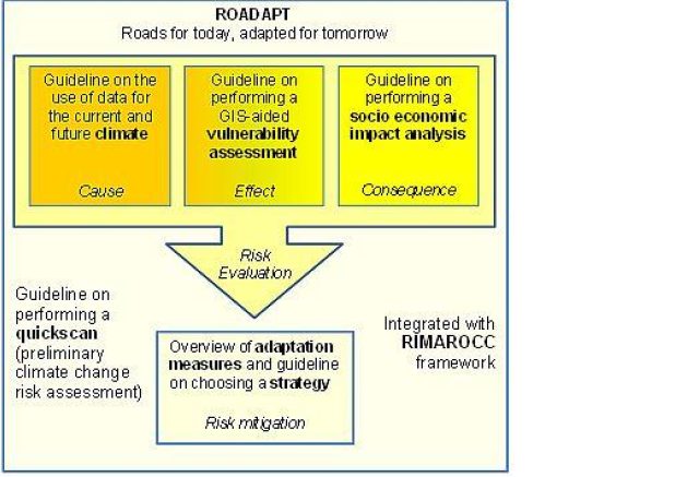
Output of the ROADAPT project is one ROADAPT-RIMAROCC integrating guideline containing different parts:
- Guidelines on the use of climate data for the current and future climate
- Guidelines on the application of a QuickScan on climate change risks for roads
- Guidelines on how to perform a detailed vulnerability assessment
- Guidelines on how to perform a socio-economic impact assessment
- Guidelines on how to select an adaptation strategy
Climate Change
Part A provides background information and guidelines for tailored and consistent climate data and information. The guideline will support studies on the impact of the current and future climate for transnational road networks in Europe, suitable for National Road Authorities (NRA’s).
The document can be used by NRA’s to judge the climate information that they receive from e.g. research institutes, consultancies, and to find answers to their questions. It can also be used by researchers and consultancies to select the most appropriate data sets and methods for a certain application. Also requirements related to climate data are given.
QuickScan
Part B provides a QuickScan method that preliminary estimates the major risks that can be associated with weather conditions both in the current climate and in the future. Another output of the QuickScan method is an action plan for adaptation. The identification and preliminary assessment of top risks allows a road authority and/or road operator to consciously and effectively focus on specific areas in their network and/or on specific threats.
The output of the QuickScan is reached by bringing all available knowledge, information, and especially experiences of stakeholders together in three workshops. Implementation of the QuickScan method in the case studies revealed that the brainstorming process in the QuickScan method is a catalyst for team building. The approach develops awareness on climate change issues, and climate-related risks in general. This helps in developing adaptation strategies.
Vulnerability Assessment
Vulnerability is assessed in a GIS environment using geographically distributed vulnerability factors describing the infrastructure and the area surrounding the road. The output is a GIS layer with areas with prerequisites for the analysed risk, and vulnerability scores. ROADAPT VA can be used for all climate-induced risks.
Socio-Economic Impact Assessment
Part D of the ROADAPT guideline deals with the socio-economic impact assessment of road traffic events. It is based on three levels of analysis:
- To increase awareness of the necessity to take climate change into account
- To introduce a risk-based approach that covers RIMAROCC and ROADAPT
- To train the participants in the use of the methodology, by making use of case studies
For each of these 3 levels, the guideline describes methodologies that enable the evaluation of the risk consequences of events linked to climate change, and in a broader manner, provides necessary information to identify the strategies to adapt to climate change.
Adaptation Measures and Strategies
Part E presents an overview of adaptation measures and helps in selecting an adaptation strategy. The guideline provides practical support in RIMAROCC step 5: Risk Mitigation. The selection of adaptation strategies follows a 10-step approach that is applied to ten specific climate change-related threats. Starting from the specific road owner’s needs, the 10-step approach helps identify relevant damage mechanisms, design models, and climate parameters for assessing the resilience of the asset in the current and future situation. Next, the approach identifies adaptation measures and strategies, assesses consequences of selecting measures and strategies, and identifies stakeholders to be involved.
Knowledge gaps in climate change projections, adaptation technologies, and essential construction and site-specific data are identified. The time to market of innovative adaptation technologies is estimated to help in the development of technology roadmaps. The guideline is supported with the ROADAPT database with over 500 adaptation measures for geotechnical and drainage assets, pavements, and traffic management.