MI-SAFE viewer
The MI-SAFE viewer offers a first step in tailor made services that will help you to include nature-based solutions into coastal protection schemes. The data and map layers in the viewer are based on state of the art science. The viewer combines world wide coastal coverage and high-resolution local analysis. It is an automated coupling of Earth Observation, water level, waves and vegetation modeling.
In a future that includes sea level rise and increasing coastal populations, shoreline defence is going to become increasingly expensive. Coastal ecosystems and their vegetation attenuate waves and stabilise sediments, providing cost-effective protection against flooding and erosion.
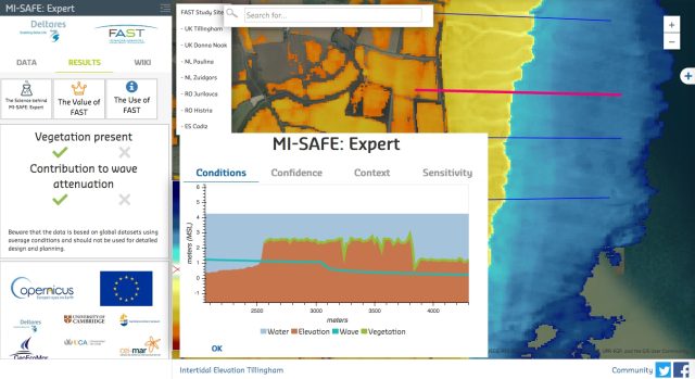
The MI-SAFE viewer is an open source and open data tool, based on Open Earth conventions, to assess wave attenuation by foreshore areas and vegetation and includes information on elevation, slope, incoming waves, vegetation presence/absence, land use cover, etc. It combines Earth Imagery and hydraulic boundary conditions with advanced numerical modelling (XBeach). These are the three modalities available:
- Educational, which is solely based on global datasets, and that indicates potential flood risk reduction effect of (vegetated) foreshores anywhere in the world;
- Expert that allows for assessing flood risk reduction effect in high spatio-temporal resolution in FAST case study areas and
- Advanced, with products and services that are available on request, aiming to provide tailor-made solutions to clients related to flood risk management and (vegetated) foreshore assessment.
The MI-SAFE viewer has been developed with funding from the European Union under the FP7 program and is the final product of the Foreshore Assessment using Space Technology project (FAST).
The viewer is supported by a consortium of Deltares, the University of Cambridge, the NIOZ Royal Netherlands Institute for Sea Research, the University of Cadiz and GeoEcoMar. More information on the involved organisations and their roles in the development of the MI-SAFE viewer can be found at the FAST website.
Five Coastal Analysis Tools
- Deltares Aqua Monitor tool
- Coastal Hazard Wheel App (CHWA)
- The MI-SAFE viewer
- UNIBEST-CL+
- The Delft3D Flexible Mesh Suite (Delft3D FM)
In addition to the Deltares Aqua Monitor tool, the first global-scale tool that shows water and land conversion, and the Coastal Hazard Wheel App (CHWA), that provides data for coastal hazards like ecosystem disruption, gradual inundation, flooding, salt water intrusion and coastal erosion, the MI-SAFE viewer adds high-resolution local analysis based on automated coupling of Earth Observation, water level, waves and vegetation modeling, using XBeach.
For the evaluation of multiple scenarios as well as sensitivity analyses of the longshore sediment transports and morphodynamics of coastlines often UNIBEST-CL+ is used. For further detailed analysis of flows and water levels, waves, sediment transport and morphology, water quality and ecology, we offer the Delft3D Flexible Mesh Suite (Delft3D FM).