
Learn more about our international work
Our work in Asia
Deltares experts and partners are investigating how deforestation and drainage of tropical peatlands in the Kampar Peninsula, Riau, Indonesia, are causing carbon loss and subsidence, which will eventually lead to flooding and production loss. This involves creation of an Elevation model using LiDAR data, and modelling of subsidence and future flooding, in a similar way as earlier applied to the Rajang Delta peatlands in Sarawak.
Since peat is not ‘land’ in the common sense but an unstable mix of water (90%) and carbon (in the vegetation remains), it will inevitably disappear when drained. As the bottom of the peat is often near Sea level, inundation and loss of agricultural production is common in such areas. This land loss is the reason that expansion of peatland drainage for agriculture was ceased in Europe and the USA by the mid-20th century. In Malaysia and Indonesia, however, development of peatlands for agriculture (mostly oil palm and Acacia plantations) has only recently started, and without considering the future flooding and carbon emission impacts.
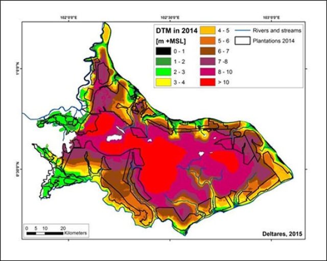
The Kampar Peninsula of 674,200 hectares is located along the Sumatra East Coast in the Province of Riau. This is the largest single peat dome complex in Sumatra and Kalimantan, and must count as one of the world’s greatest peatlands. It also has the deepest peat (at least 4.9 m on average with many areas exceeding 10 m in depth), greatest peat carbon stock (at least 1.6 Gt C) and the greatest remaining area of peat swamp forest in Sumatra. However, in the last 15 years some 294,227 ha or 43.6 % of this landscape have been converted to pulp and oil palm plantations, mostly in a zone closest to rivers and the coast. While the remaining central peat forest area is still mostly in good condition, the deforested and drained area inside and around plantations is rapidly losing carbon and subsiding.
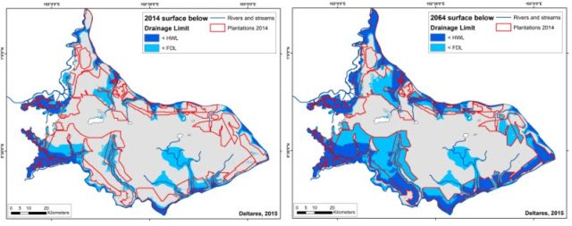
Already, 31 % of the plantation area on the Kampar Peninsula is probably subject to drainability problems and/or flooding. Within 25, 50 and 100 years, 71%, 83% and 98% of the existing plantation area is projected to experience drainability problems and/or flooding. Meanwhile, carbon loss caused by peat oxidation in plantations, excluding fire emissions, emissions from drainage affected areas outside of plantations as well as the original drainage spike following drainage, amount to at least 4.4 Mt C yr-1.
This study was commissioned by Wetlands International and funded by CLUA and Norad.