JMP-EUNOSAT: Eutrophication assessments North Sea using satellite data
The JMP-EUNOSAT project has developed a new method for monitoring and assessment of pollution with nutrients (eutrophication). Excess nutrients stimulate algal growth, which can result in lack of oxygen and light under water for plants and animals. EU member states need to report every 6 years on the water quality of their seas for the Marine Strategy Framework Directive (MSFD).
These reports so far show an incoherent representation of water quality, due to the use of different threshold values and monitoring methods between countries. Threshold values are defined as 50% above the natural background concentration for all countries around the North Sea.
However, countries have used different approaches to estimate these background concentrations, leading to incoherent threshold values. The European Commission has asked countries to improve on this so future assessment reports will give a good overview of the level of eutrophication in the North Sea.
A new common method, using satellite data
The JMP-EUNOSAT project (Joint Monitoring Programme of the Eutrophication of the North Sea with Satellite data) has developed a new common method for monitoring and assessment of eutrophication in the North Sea:
- Threshold values for nutrient and algae concentrations are derived with the same method for all countries;
- The North Sea is subdivided in areas with similar ecological functioning for the assessments;
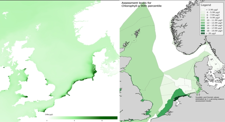
- Quality controlled satellite data are used as additional common source of information on algae concentrations;
- countries collaborate to improve the coherence and cost efficiency of their data management and reporting.
Throughout the project progress and plans have been regularly communicated with representatives from all countries involved, united in OSPAR. At the end of the project these countries have agreed to test the newly developed approach for their upcoming eutrophication assessment reports, in comparison with the current method. To this end the assessment areas and threshold values, including underlying models, will be further refined and discussed between countries.
Back in time
For the definition of natural background concentrations the project proposed to use the year 1900. During this period human impact on the environment was relatively limited. Natural background concentrations are highest near river mouths of large rivers, such as along the Dutch coast.
Nutrient inputs from rivers to the North Sea have been estimated by SMHI (Sweden) with their hydrologic model of Europe. Next, Deltares used these inputs in their models to estimate corresponding nutrient and algae concentrations throughout the North Sea. Field observations of nutrients and algae are only available for recent years. Therefore we also ran the models for recent years, to check if the models can reproduce recent field observations. New threshold values have been derived as 50% above the model estimated concentrations for 1900.
Rijkswaterstaat (NL) coordinated the project. Deltares was responsible for the new threshold levels and definition of similar areas. RBINS (BE) developed a spatially coherent satellite product for algae and Arhus University (DK) coordinated the approach for collaboration for monitoring and assessments. In total 14 project partners were involved, from all countries bordering the North Sea. Project reports are available.
This project was financially supported by contract nr. 11.0661/2017/750678/SUBIENV.C2 of DG-Environment part of the “European Maritime and Fisheries Fund” 3rd call: “Implementation of the second cycle of the MSFD”