
UNIBEST-CL+
An increasing number of people live and work in coastal areas. The natural environment makes it an attractive place to settle. The coastal areas are also essential for the worlds industries, as they largely depend on the sea transport routes. This results in an expansion of urban and industrial developments along the coast. Consequently, questions will emerge with respect to safety, recreation, urban planning, port design and ecological impacts of human induced changes.
Coastlines are dynamic systems requiring state-of-art models to address coast related questions. This holds especially for ‘soft’ coastlines like beaches which mainly consist of sediments. The existing shoreline position is often the result of a delicate balance between eroding and accreting forces.
Changes in position of the shoreline may therefore occur on different temporal scales (months to decades). The driving factors for these changes can be natural or due to human induced measures.
Both natural and human induced changes to coastlines have been studied by Deltares in a wide variety of research and engineering projects. Throughout the years, the coastline model UNIBEST-CL+ has been developed.
In applications on coasts world-wide it has proven to be a flexible and easy-to-access tool capable of simulating a large variety of coastal problems. The model is able to handle complex coastline shapes, includes state-of-art sediment transport formula and has a flexible user interface.
Technical specifications
The program UNIBEST-CL+ is a powerful tool to model longshore sediment transports and morphodynamics of coastlines. Shoreline migration is computed on the basis of computed longshore transports at specific locations along the coast.
If required the effect of cross-shore phenomena can be assessed with the UNIBEST-TC and UNIBEST-DE modules. The UNIBEST-CL+ model runs are very time-efficient, which allows for the evaluation of multiple scenarios as well as sensitivity analyses.
Applications
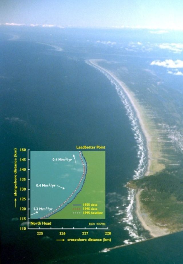
The shoreline model UNIBEST-CL+ can be used for a wide range of coastal engineering projects. A typical application is the analysis of the large scale morphology of coastal systems to provide insight into the causes of coastal erosion or to predict the impact of planned coastal infrastructure (such as a port) on the coast.
Shoreline evolution computations can be made over a period of decades, but also for considerations on a smaller time and spatial scale. It is possible to evaluate the shoreline evolution around coastal protection works (groynes, revetments, river mouth training works and to some extent detached breakwaters).
Shoreline schematisation
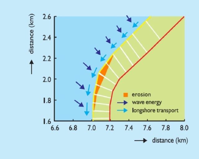
The shoreline is defined relative to a user-defined reference line which may be curved. This enables the modelling of complex coastal areas such as deltas, bays, circular shaped beaches and even complete islands. In these computations changes in the longshore transports with time due to re-orientation of the shoreline are taken into account.
Processes
The model includes a wave propagation module to transform the offshore wave climate to the surf zone (assuming fairly uniform depth contours) and to compute the surfzone dynamics, according to the Battjes-Stive model (1984) for wave propagation and wave decay. Principal processes are accounted for, such as changes in wave energy as a result of bottom refraction, shoaling and dissipation induced by wave breaking and bottom friction.
The influence of the rotation of the active part of the cross-shore profile on wave refraction is accounted for through an automatic determination of the dynamic boundary. The distribution of the longshore current along the coastal profile is derived from the depth-averaged momentum equation alongshore. A number of wave-current interaction models (Soulsby et al., 1993) can be used to compute the relevant bed shear stresses.
Longshore transport and its distribution along the coastal profile can be evaluated according to several sediment transport formulae. This concerns formulations that relate transport of sediment to wave energy (like CERC and Kamphuis 1991) or process based formulations (like Bijker, Soulsby/Van Rijn, van Rijn 1992, Van Rijn 1993 and Van Rijn 2004). Furthermore, a formulation for gravel transport is available (Van der Meer & Pilarczyk).
The transports respond to local wave- and current conditions in an instantaneous, quasi-steady way. The net longshore transport can be computed on the basis of (up to) hundreds of combinations of wave- and tidal conditions. Also the gross contributions in both directions can be derived.
An essential aspect of coastline modelling is the strong relationship between the orientation of the coast and the longshore transport for each cross-shore ray. This relationship is presented in a socalled S-ϕ curve. This curve forms the basis for the shoreline modelling since it provides information on transport gradients caused by a curvature of the coastline, as well as on the timedependent response of the longshore transport on changes of the coast-orientation with time.
GIS Functionality
UNIBEST-CL+ includes GIS functionality (MAP-Objects™), which allows for setting up models in a graphical way. The user can use satellite images, maps or AutoCAD drawings as a basis for the model. The location of the coastline and structures can then be specified interactively on the map. Layers with different parts of the model can be switched on and of depending on the user’s preferences.
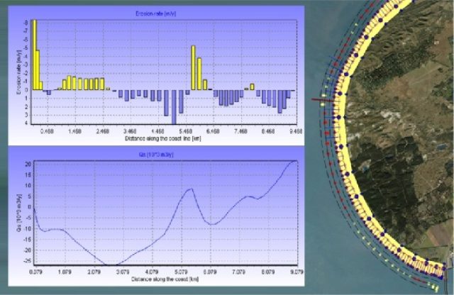
UNIBEST-CL+ plots the model results, like accretion and erosion rates along the coastline, directly on top of the background layers (maps, images or AutoCAD drawings). Movies with computed coastline changes can be created with the user interface.
Tables and graphs can be created which present longshore sediment transport, coastline position or rates of coastline change (accretion or erosion). Detailed information can be exported to output files in ASCII or comma separated format.
Link with other models
UNIBEST-CL+ offers the option to retrieve information from the sophisticated 2DH wave propagation model Delft3D-WAVE (based on SWAN). This model can be used for the wave transformation for situations with complex bathymetries or large structures (harbour moles or offshore breakwaters).
The user can extract wave climates at nearshore points in an interactive manner from the 2DH wave fields. The GIS functionality of UNIBEST-CL+ allows for the visualisation of local wave climates and bathymetry of Delft3D-WAVE output files.
With this option the development of the shoreline in and adjacent to the shadow zones of offshore islands, harbour moles and (large) detached breakwaters can be computed on the basis of detailed wave modelling in a time-efficient and flexible way.
Future developments
A number of enhancements are worked on for the next release. This includes, amongst others, an option to use wave time-series instead of wave climates. Furthermore, practical functionality will be added like simple di ffraction and sheltering routines near to coastal structures, improved input and output definition and batch functionality.
Model organisation
UNIBEST-CL+ runs on Windows-based systems and is controlled by a user-friendly interface in which input files can be created and edited, simulations made and model results graphically inspected. The various input fields are stored in different ASCII files, enabling the user to store and link different input combinations to the runs.
This information is administrated in special fles which allows for the creation of scenarios (combinations of measures) in the coastline model. For the longshore transport computations a facility is provided to execute a large number of consecutive (sensitivity) runs.
Model input:
- wave climate: significant wave height, wave period, wave direction and percentage of occurrence of each condition
- tidal regime: current velocities, water levels and percentage of occurrence of each condition coastal profile shape, active zone and active profile height
- sediment: characteristics of sand or gravel (non-cohesive sediment)
- parameters related to the selected sediment transport formula
- parameters for wave propagation
- coastline shape / position
- boundary conditions for shoreline model
- structures: groynes, offshore breakwaters, revetments, sources/ sinks
- scenarios defining the coastline model runs (with combinations of above input)
Model output:
- wave characteristics along the coastal profile
- cross-shore distribution of the longshore currents (wave-induced and tidal)
- cross-shore distribution of the longshore transport
- relations between longshore transport and coast-orientation
- gradients in longshore transport along the coastline
- coastline position, migration and orientation between grid points
- coastline migration rates between grid points
