Tackling drought and water shortages
Drought and water shortages pose a serious threat to prosperity and well-being worldwide. To address drought risk, particularly against the background of climate change, Deltares is helping governments, basin authorities and other stakeholders to develop long-term strategies to tackle drought and water shortages.

Many regions in the world have already been hit hard by drought events in recent years. In the summer of 2023, regions throughout the Northern Hemisphere suffered from extremely dry weather conditions, with high temperatures, droughts and bush fires, for example in Northern America, particularly Canada, and Europe.
Research shows that it is realistic to expect a doubling by the end of this century in the land area worldwide that will be affected by extreme drought. In that scenario, half a billion people will be affected by drought and a shortage of fresh water. Not only because of lower river discharges and falling groundwater levels, but also because evaporation and salinisation will increase. All against a backdrop of rising demand for water for agriculture, industry and residents. The crux is often the transnational balance between supply and demand. Water is no respecter of national borders.
An integrated problem such as drought requires an integrated and area-oriented approach. With water and the subsurface as a recurring theme, Deltares connects the various challenges and transitions for a future-resilient and sustainable living environment.
Marjolein Mens, surface water and delta management specialist
Analysis of Dutch drought in recent years
Since 2018, the Netherlands has suffered from several extremely warm, sunny, and dry years. After the 2018 drought, a large ‘Drought Policy Platform’ was established, drafting a range of recommendations for implementation in the short term by different organisations.
With our partners, we are investigating the effects of the drought of 2022 to determine the impact on the water system and the associated consequences for nature, wildfires, agriculture, shipping, land subsidence and carbon emissions from peatland, drinking water, energy, industry, urban areas and dyke integrity.
Important questions include: ‘how much impact was there on society, which data are available for the analysis, and can we explain the impacts on the basis of system knowledge?’ On the basis of these research results, Deltares held discussions with several water managers and policymakers such as STOWA and the Dutch Freshwater Delta Programme that resulted in recommendations for policy and research: ensure there is sufficient knowledge, monitor the impacts and prepare for future periods of drought to limit the consequences.
Water shortages in the Netherlands as a spatial challenge
Water shortage is also a spatial issue. Robust solutions to minimise the impact of drought in the Netherlands require interventions in spatial planning. And sometimes even changes in land use to achieve a better match with water availability. For example, the project Climate Adaptation In Practice (KLIMAP). Within the four-year KLIMAP programme, a partnership of 24 parties is investigating which measures and changes in the use of land and water are feasible and effective.
In addition, it is being investigated which joint process must be followed to adapt the sandy areas in the Netherlands to the changes in the climate. These objectives are addressed through a seven-step roadmap, developed by Deltares. A central focus of this roadmap is the visualisation and quantification of possible future scenarios according to the Development Paths system.
How can we retain water in climate-adaptive ways, what are the best locations for agriculture and where do we create room for nature? Our experts provide the quantitative basis for the adaptations that are required. For example in the Freshwater Delta Programme. Looking to our future, Deltares is currently conducting a range of strategic reconnaissance studies in interdisciplinary alliances and providing input for organisations such as the Dutch Environmental Research Agency (PBL) and the Delta Commissioner's Staff.
Optimal water distribution
Water can be distributed in smart ways during droughts. Technical solutions contribute to enhancing freshwater stocks by means of, for example, artificial infiltration and the limitation of salt intrusion. Climate change and socio-economic developments mean that water availability is less self-evident than it has been in many countries. It is important to place the choices that are now being made in a long-term perspective by exploring the future in scenario analyses supported by data and models.
International water distribution issues
Internationally, drought in particular raises questions about optimal inclusive distribution. We map out drought risks worldwide. For example in the drought catalogue for the World Bank, which also contains recommendations for sustainable operational management. We are also the co-author of the EPIC Response: Innovative Governance for Flood and Drought Risk Management. We provide factual information that is used to make decisions. For example in Cape Town and Sao Paulo, where we advised local civil servants and users.
Globally, freshwater resources are coming under pressure from the rapidly increasing effects of climate change. Availability and quality of water resources and associated socio-economic developments are affected. We help river and river basin managers prepare. Among others in Stars4Water an collaborative EU project.
Water distribution between countries also requires this specialist knowledge because of the substantial investments made by governments and financial institutions. We do that by modelling action and interaction in the system alongside the physical processes (agent-based). We do this ‘water accounting’ at the global, local or catchment levels.
Infographic about drought
Click on the infographic about drought for more information.
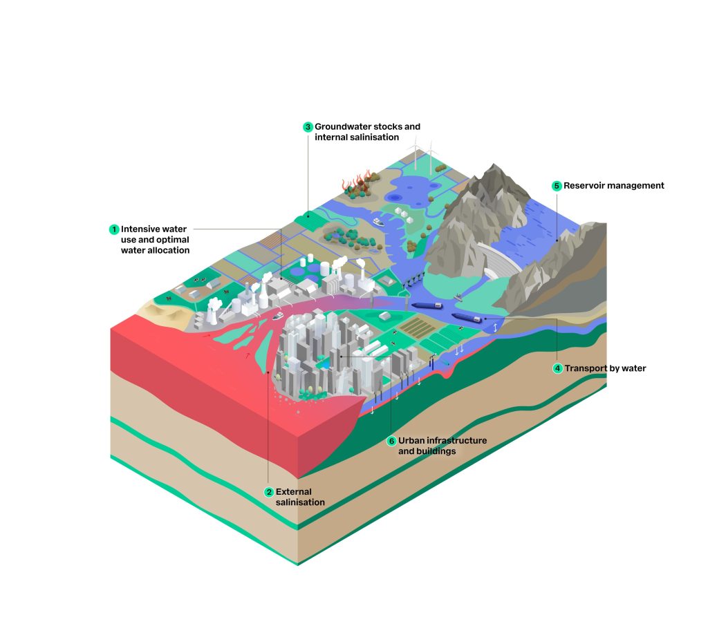
This infographic shows a cross-section of a landscape with six important aspects of water management:
- Intensive water use and optimal water allocation – Efficient use and distribution of water resources to meet the demands of agriculture, industry and households.
- External salinisation – Intrusion of salt water into freshwater areas, often caused by sea level rise or low river discharge, with negative consequences for agriculture and drinking water.
- Groundwater stocks and internal salinisation – Storage of groundwater and the risk of salinisation within the system, which affects the availability of freshwater.
- Transport by water – Use of rivers and canals for the transport of goods and people, essential for the economy and logistics.
- Reservoir management – Management of water storage in reservoirs and basins to regulate water supply, irrigation and flood control.
- Urban infrastructure and buildings – Development of urban areas with attention to water management, such as sewerage, drainage and climate adaptation.
Salinisation and innovative concepts on the coast
Our experts provide the quantitative basis for the adaptations required to counteract salinisation. For example in the case of large locks. Smart approaches to designing and managing these structures, which are important for the delta, will allow more fresh water to be kept available for other functions. These innovative concepts for engineering structures are also tested in our research facilities.
In Saltisolutions, we are teaming up with universities, Rijkswaterstaat, and engineering and consultancy firms to study salt intrusion in order to develop better measures and policy together.
Sustainable management of groundwater stocks

How can we manage our groundwater in a sustainable way? At the regional level and the level of individual plots of land, we are working on the Grow with the Flow platform that gives growers, water authorities and the food processing industry a clearer picture of water availability. We are involved in projects to study ways of saving winter precipitation in freshwater lenses for coastal areas - COASTAR.
In addition, we are also working internationally on a method to investigate the risks of salinisation in the current climate and in the future for estuaries. In the Mekong delta, for example, the ongoing salinisation of groundwater is a threat to supplies of food and drinking water. Here, our FAME project is contributing to the availability of fresh groundwater.
Transport by water

Droughts put pressure on water transport because of lower river discharges and lower water levels in the rivers. Waiting times at locks get longer as locking procedures are adapted to save water and shortened to prevent salt intrusion. At the same time, the European ambition is actually to transport more by water. Working with inland shippers, waterway managers and universities, Deltares is addressing the issue of climate resilience in the Netherlands and abroad.
We conduct stress tests looking at the long-term consequences of drought (including soil erosion) and the options for integrated measures by, for example, developing a digital twin of the fairway corridor to Basel. We inform shippers about the current and near-future water depths for optimal loading and sailing (CoVadem), and produce long-term forecasts of water depth for more strategic decisions. We help waterway authorities worldwide, including the world-famous Panama Canal, to tackle salinisation.
Sponge effect to tackle drought and biodiversity loss
With the increasing changes in drought and precipitation, ‘water and soil as leading factors’ is becoming the new standard. This raises the question of whether the sponginess of the land can be used to retain the water that falls during wet periods for longer. This NbS results in fewer problems with dry conditions and provides opportunities to include the biodiversity agenda in the selection of measures.
We are working to
optimise the quantification of natural water storage and the link with
biodiversity indicators. That work is done in, for example, European
projects such as MERLIN, REXUS and Spongescapes.