Deltares peat mapping in Indonesia – status update
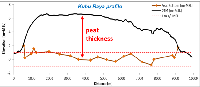
In 2017 Deltares, together with ITB (Institute of Technology Bandung), submitted a rapid and cost effective peat mapping method to the Indonesian Peat Prize that applied an elevation model (DTM) created from airborne LiDAR data, and limited field measurements of peat thickness. The position of the peat bottom is determined by subtracting the peat thickness from the DTM, and peat thickness is mapped as the difference between peat surface model (DTM) and peat bottom model (Figure 1).
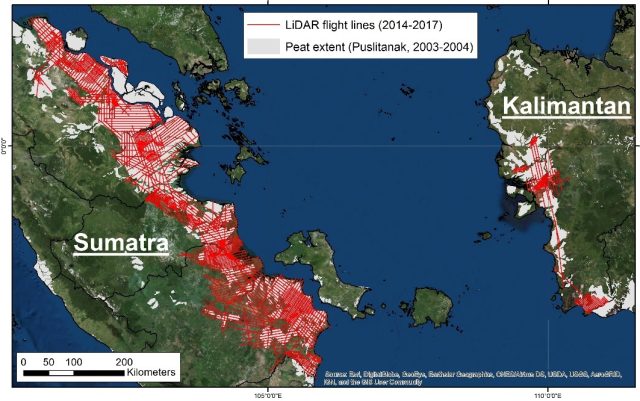
The LiDAR data collected by Deltares is flown along transects and covers 10% or 30% of the area to reduce cost relative to full LiDAR coverage. It was determined that this approach is accurate within 0.5 m for at least 95% of the mapped area (compared to a full coverage DTM), which is considered sufficiently accurate for most applications, including peat mapping. Such LiDAR data were already collected over 2014-2017 for most of East Sumatra lowlands and parts of West Kalimantan, funded by several donors including APP (Asia Pulp and Paper), UKCCU (United Kingdom Climate Change Unit) and NORAD (Norwegian Development Corporation), with a total landscape coverage of >6 million ha (from ~2 million ha of actual LiDAR coverage) along 30,000 km of flight lines (Figure 2).
The method that won the Indonesian Peat Prize (on 2 February 2018), submitted by the International Peat Mapping Team, is similar and complementary to the Deltares method, because both apply a DTM and limited field measurements. The IPMT method proposes a range of methods that may be used to develop DTMs, including LiDAR along transects as applied by Deltares.
DTMs and peat thickness maps will be made available by Deltares in the public domain in 2018, with methods published in scientific journals, as a contribution to peat mapping in Indonesia.
More information
-
Peat thickness mapping using LiDAR derived DTM and limited peat thickness field measurements (4,72 MB)
-
Peatland mapping for Bengkalis Island, Riau, using limited LiDAR data and peat thickness field measurements (4,94 MB)
-
Peatland mapping for Kubu Raya, West Kalimantan, using limited LiDAR data and peat thickness field measurements (5,54 MB)
-
ITB