Port of Salaverry siltation and maintenance dredging program
Deltares assisted Salaverry Terminal Internacional (STI, the operator of the Port of Salaverry, Peru) by predicting the port's maintenance dredging needs and advising on the technical feasibility of conceptual solutions to reduce the maintenance dredging volume and interval. This advise was based on analysis of in-situ collected and publicly available data and numerical modelling with Delft3D.
Following a capital dredging campaign carried out by STI to deepen the port basin and approach channel, the Deltares study was initiated after depth measurements taken a few months later indicated that the depth in large parts of the port had decreased substantially, rapidly approaching the minimum required depth. This caused a short-term risk for the safe navigation of ships and implied potential high maintenance dredging costs to the Port.
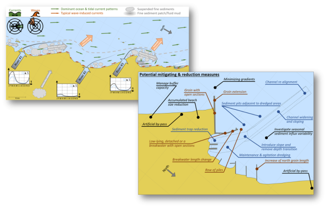
Deltares conducted a two-phased study approach. First, a desk-study was carried out to identify the regional and local sediment dynamics in the Port of Salaverry area, based on data collected by STI and available in the public domain, such as satellite imagery. It was identified that in distinct areas of the port, fluid mud formations dominated the sediment deposits, whereas more silty and fine sand deposits characterized other areas of the port. This detailed understanding of relevant sediment dynamics provided a basis to a long-list of conceptual mitigation measures, proposed to re-establish safe navigation of ships and reduce future maintenance dredging needs.
In a more extensive follow-up study phase, Delft3D hydrodynamic and sediment transport models were setup, calibrated and validated with in-situ collected data. These models were used to assess the technical feasibility of several structural and dredging alternatives that could potentially minimize sediment ingress in the Port. The outcomes of these analyses contribute to the optimization of the port sediment management. Simultaneously, the detection of fluid mud in the port basin initiated additional investigations into characterizating this deposit, as well as under which fluid mud conditions vessels could safely sail through the fluid mud deposit.