New global projections of tides and storm surge available based on high resolution climate models
Expert(s) |
Sanne Muis
|
Kun Yan
In the coming decades, the frequency of coastal flooding will increase due to sea-level rise and changes in climate extremes, putting the millions of people living in low-lying areas at risk. The increased flooding frequency will be driven by sea-level rise, but changes in storms that generate hazardous storm surges may contribute. To inform climate mitigation and adaptation efforts, there is a need for accurate information on extreme sea levels and how they change under global warming.
State of the art modelling
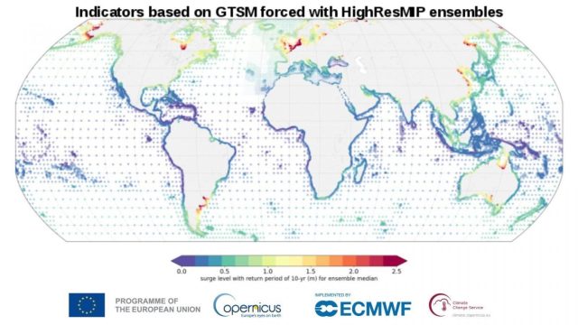
To this end, Deltares has updated the global projections of extreme sea levels. The projections are derived with the Global Tide and Surge Model version 3 (GTSMv3.0). GTSM is a depth-averaged hydrodynamic model with global coverage. The resolution is spatially varying which allows for a high accuracy in coastal areas while being computationally efficient. To simulate extreme sea levels, GTSM was forced with climate simulations from the High Resolution Model Intercomparison Project (HighResMIP).
“This dataset is a big leap forward compared to previous work” says Sanne Muis, developer of the dataset and researcher at Deltares and Vrije Universiteit Amsterdam. “This is the first time that a multi-model ensemble of global storm-resolving climate models is used for this purpose.” Compared to the previous Pan-European dataset, there are a few other innovations. The coverage is extended to global. Interactions effects between tides and mean sea levels are included for both the historical and the future time periods and more advanced extreme values statistics were implement.
Long term climate projections including statistics
The dataset provides both timeseries of tides, storm surges and total water levels from 1950 to 2050, as well as statistical indicators for three time slices. The statistical indicators include various return periods of storm surges and total water levels and various tidal water levels. The dataset can be used to assess the vulnerability of the coastal sector to climate change. For example, users may apply the data for flood risk assessment or management plans of coastal erosion. To provide detailed information at regional scale, the dataset could be used for dynamic downscaling.
International collaboration
The development of such a rich dataset is computationally intensive with millions of core hours on a supercomputer and many terabytes of data. The calculations were carried out in a collective effort with researchers from the Vrije Universiteit Amsterdam, USGS, IHE Delft, and PIK. Researchers from KNMI and UK MetOffice provided the climate and sea level rise data. Together with Copernicus Climate Change Service (C3S) and Climate Data Store, we have made the full dataset (time series and indicators) openly available. “We are very pleased to make this rich dataset freely available” says Kun Yan, project leader at Deltares. “The dedicated service at the CDS web portal allows users to select specific points or variables of interest and they will be able to easily retrieve or visualise the data.”