3D model for computation of water levels, currents and temperatures
The North Sea is one of the most heavily used seas, with resulting competition between nature, transport, recreation, energy and food supply. How will an offshore wind farm affect the hydrodynamics and transport of fine sediment in this unique ecosystem? What impact does climate change have on water levels along North Sea coasts? Such questions can only be answered with sound system knowledge. Deltares now presents a new, advanced 3D model for the computation of water levels, currents and temperatures in the greater North Sea: the 3D Dutch Continental Shelf Model – Flexible Mesh (3D DCSM-FM).
The 3D DCSM-FM sets a new standard for the 3D modelling of regional hydrodynamics. It is used for operational water and coastal management, and for further research. The model combines currents, water temperature and salinity with water levels (tide and storm surge). Both short-term and long-term developments can be assessed clearly, at both local and large-scales. The model provides insights into the fate and interactions of complex natural phenomena in coastal waters and the open sea. It covers the Northwest European Continental Shelf, which includes the entire North Sea from the Irish Sea to the Baltic Sea and from the coast of Northern Spain to the coast of Scandinavia.
Efficient use of computational resources
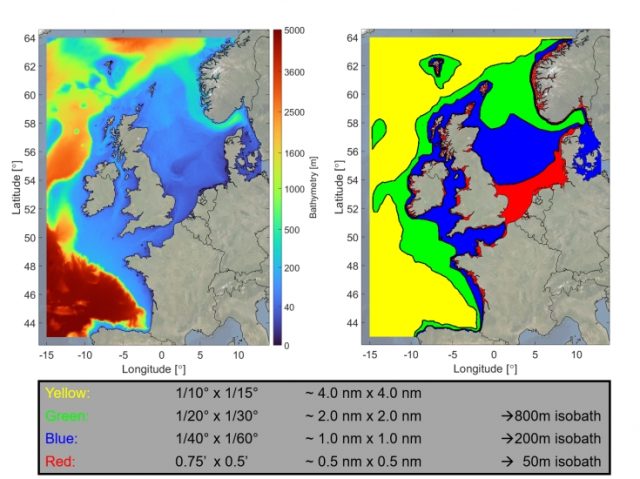
The 3D DCSM-FM model domain includes both deep oceanic and shallow coastal waters. A flexible mesh (allowing a combination of coarse and fine grid cells) allows for both precise and relatively fast calculations in a single integrated model.
The model has a high resolution in shallow waters for an accurate description of the local physics in these shallow areas with a variable bathymetry and coastline. A lower resolution (and thus less computational effort) is adequate for deeper waters further offshore. This allows the 3D DCSM-FM to use computing power most efficiently
State of the art
Model predictions and observations have been brought together to calibrate the model for a wide variety of applications. Extensive validation using large numbers of measurements has shown that the model simulates natural processes excellently. The ability to reproduce water level information accurately is very good.
Compared to earlier 3D models of the southern North Sea, the error in the prediction of water levels for the Dutch coast has been reduced by up to 75 percent. As a result of developments in the standardisation and availability of European bathymetric data, 3D DCSM-FM also provides a more faithful representation of the seabed in comparison with previous models. This results in a more accurate propagation of tides and storm surges in the southern North Sea.
Another important improvement is that the 3D DCSM-FM can accurately calculate seasonal temperature differences in the water column (temperature stratification) in different years. This benefits its suitability for applications to water quality and ecological modelling. Coupling of the model to other software modules can also extend the range of possible applications.
What does the model show?
In the first place, the 3D DCSM-FM focuses on representing hydrodynamic information such as water levels, currents, temperature and salinity. Water temperature and salinity determine the density of water. This can result in different water layers (stratification) and provides information on the extent to which water layers mix (due to turbulence). It is therefore possible to analyse transitions between fresh and salt water, such as those between river systems and the sea.
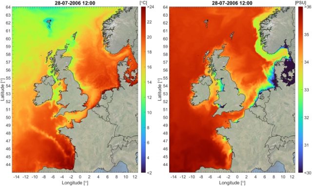
Surface temperature and salinity calculated by the 3D DCSM-FM
By linking meteorological information to the 3D DCSM-FM, it becomes clear how wind and weather affect water levels, water temperatures and the vertical mixing of the water column. This allows the forecasting of water levels on a day-to-day basis. Combined hydrodynamic and meteorological information also often underpins studies of coastal management, coastal protection and the development of new user functions on the continental shelf, such as energy production in offshore wind farms.
The 3D DCSM-FM can be expanded with ease to model the transport of suspended sediment and/or dissolved substances. In that way, it is possible to establish a picture of sediment concentrations and the distribution of nutrients. In combination with information about temperature and turbulence, this enables detailed water quality models to be developed. It is then only a small step to generate information that is relevant from an ecological point of view: do conditions improve or deteriorate for certain species? Is there a possibility of algal blooms?
In the context of climate change, the computer model serves as an excellent tool to downscale global phenomena and trends into smaller-scale situations: what is the effect on water levels in the North Sea due to sea level rise as a result of melting polar ice? What degree of sea level rise is critical for weak spots in various European coastlines? By making calculations for different scenarios, the model delivers fundamental knowledge to underpin long-term coastal management.
Applications: practical information and strategic knowledge
The 3D DCSM-FM model offers new possibilities for statutory water level forecasts. In the Netherlands, these forecasts for Rijkswaterstaat are currently based on information from 2D, depth-averaged models. 3D DCSM-FM offers all water authorities in countries that border the North Sea the possibility to forecast tides and storm surges accurately. In a completely different context, the model has been used in the past to provide competitors in the Volvo Ocean Race with information about currents.
On the European scale, the model has been used to chart the movement of concentrations of nutrients in river discharges and at sea. This analysis serves as a basis for the standardisation of nutrient emissions to the sea for all European countries. Sediment transport has been modelled as a basis for a maintenance strategy for the sandy Dutch coast. Scientists from research institutes such as Delft University of Technology also use the 3D DCSM-FM to conduct more fundamental research related to geodetic applications and data assimilations.
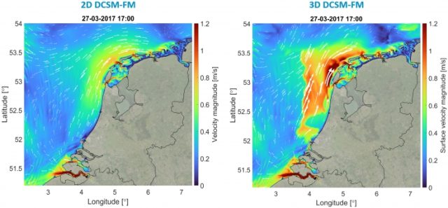
Development of offshore wind energy is also expanding rapidly. Offshore wind farms affect the water system in at least two ways. Firstly, the wind turbines extract energy from the wind, which changes the wind climate and the subsequent wind-driven effects on waves and water levels. Secondly, the presence of the wind turbines changes conditions below the waterline. The 3D model can show the impact of the large-scale construction of offshore wind farms on currents, stratification, water quality and ecological status.