Global modelling of tides and storm surges
Extreme sea levels, caused by storms and high tides, can cause coastal flooding and erosion. With sea-level rise and climate change, low-lying areas around to world will experience increased risks. To mitigate these risks, there is a need for accurate forecasts on when and where extreme sea level will occur and a good understanding how risks will change in the future. To this purpose, Deltares has developed the Global Tide and Surge Model (GTSM).
GTSM is a depth-averaged hydrodynamic model with global coverage. GTSM can be used to dynamically simulate water levels and currents, that arise from tides and storm surges. The model uses the Delft3D FM Suite, and has a spatially varying resolution. Because of this, GTSM has a uniquely high resolution at the coast, which makes that coastal water levels are accurately resolved while being computationally efficient.
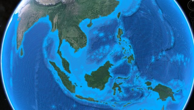
The model development is an ongoing and continuous effort. We have recently released GTSMv4.1, which has a coastal resolution of 1.25 km. With each new version of the model, we incorporate higher spatial resolution, improved representation of physical processes, updated input datasets such as bathymetry, and improved calibration. From GTSMv2.0 to GTSMv4.1, the model performance showed great improvements with a 50% reduction of the root-mean-squared-error between modelled and observed tides from 22.3 cm to 11.3 cm.
GTSM is a self-contained model with no data assimilation and boundary conditions. As such, the model can be easily applied with different settings (e.g. tide-only, surge-only or combined mode), and forced with different climate data (e.g., forecasts, reanalysis or scenarios). Non-linear interaction effects between tides, storm surges, and sea-level rise can be included in the simulation.
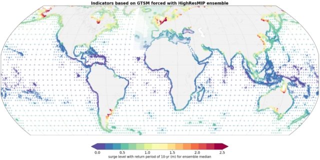
There is a broad range of applications and (research) projects that make use of GTSM, which include operational forecasting, reanalysis of historical extremes, and climate change projections. Using GTSM as a basis, the Global Storm Surge Information System (GLOSSIS) provides 10-day tide and surge forecasts that are updated four times a day. GTSM has also been used to simulate historical water levels and estimate return periods of extremes. These return periods form the basis of many large-scale assessments of coastal flooding and risk, for example, for the Aqueduct Flood Risk Analyser of the World Resources Institute. We have also developed future projections of extreme sea levels for different climate scenarios (Figure 2). This dataset will be openly available at the C3S Climate Data Store.
For a more detailed overview of the main model developments and applications, including a list of open-access datasets and publications, and the latest updates, we refer the reader to GTSM public wiki.