Sea level on Dutch coast rose further in 2022
Expert(s) |
Marcel Taal
Today Deltares presented the annual calculation of the sea level on the Dutch coast. The last, more comprehensive, four-yearly, report noted for the first time, in addition to the worldwide observation, an acceleration in sea level rise along the Dutch coast. That conclusion has been confirmed now that the data for 2022 have been added. The sea level data on the Dutch coast can, as concluded last year, best be described by a trend of 1.8 mm/year until thirty years ago, and an increase in the average annual rise to 2.9 mm/year thereafter.
Since 2014, Deltares has been updating the Sea Level Monitor for the Ministry of Infrastructure and Water Management. The monitor determines the status and development of the sea level to support policies for flood risk management. The results of the Sea Level Monitor are used to determine issues such as the annual requirement for sand nourishment. The monitor also plays a role in the assessment and design of the primary flood defences.
The annual sea level status is based on observations from the six main tidal stations in the Netherlands (Delfzijl, Harlingen, Den Helder, IJmuiden, Hoek van Holland and Vlissingen). The Delfzijl monitoring station is currently being carefully checked by Rijkswaterstaat. It is therefore not included in the calculation, as was also the case last year. The average sea level for the year 2022 was 9.5 cm above NAP. After correction for wind surge and tides, the water level was the highest ever (see figure).
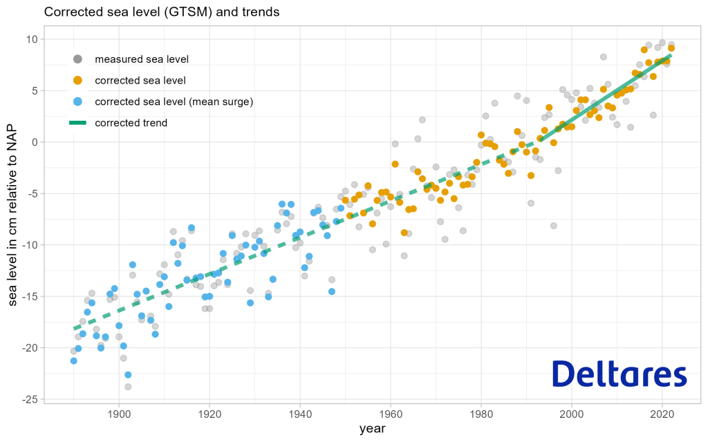
Over the past year, Deltares was able to determine the sea level even more accurately, thanks to advanced analysis techniques that calculate the impact of wind on sea level better. In addition, it is possible to look back almost an extra thirty years (to 1950 instead of 1979). However, this did not affect the conclusions on the trends in sea level rise.
Martijn Klein Obbink (Rijkswaterstaat): Monitoring the sea level is extremely important for the Netherlands. The Sea Level Monitor provides us with a good picture of the current rise on the Dutch coast. Rijkswaterstaat and KNMI will continue to monitor sea level rise closely in the years ahead."