Joint model for tackling groundwater pollution in the port and city of Rotterdam
To facilitate the megasite approach to pollution in the port of Rotterdam, Deltares has built a large-scale groundwater model called CARROT (Coordinated Approach Remediation ROTterdam) over the past fifteen years.
The model consists of several components:
- a flow model for the entire port with a coarse model resolution;
- models for groundwater flow with a fine resolution for the Botlek, Europoort, Waalhaven, Eemhaven, Stadshaven and Vondelingenplaat areas and
- local transport models for the pollution plumes from specific industrial areas.
Since 2019 the model is in place for the whole city area of Rotterdam.
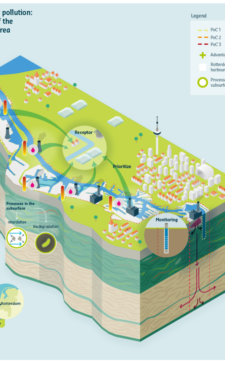
Complexity of the situation requires a new and different approach
The complexity of the groundwater pollution (the substances and reactive processes) required a new approach, for which the iMOD method was very suiteable. All data files are stored in a central database and automatically scaled up or down depending on the model resolution required. All the model data and the required computing capacity are available via a server hosted at Deltares and they are accessible for the municipality and port authority, as well as companies located the area.
Information about the subsurface, groundwater and surface-water system, fresh-salt groundwater, geochemical characteristics, microbiology, type of pollution, reactive transport, and the uncertainties and risks are all included in the CARROT model. The model has steadily improved in recent years as the calculation speed has increased and new knowledge and data has been acquired about biodegradation processes in the subsurface.
What does this groundwater model do for users?
The results of the groundwater model make the following possible for the municipality of Rotterdam, the port authority and the companies located in the area:
- The establishment of a of a strategy and associated measures: The model results provide an insight into the possible spreading of pollutants towards the area boundary and towards deeper layers. In addition, the results show how fast this happens. This information can be used to determine whether removal at source or other measures are appropriate. Measures can also be assessed with the model to determine their effectiveness.
- To design monitoring systems: The results show in which direction and how quickly pollution is transported by the groundwater. This information can be used for the smart design of the monitoring network. In turn, this targeted monitoring approach generates data that can be used to improve the model.
Knowledge about the natural degradation of pollutants
An important parameter in the model is the natural degradation of pollutants. In-depth studies are conducted into the natural degradation of benzene, tar and other substances like MTBE/ETBE and TBA. The results are used to update the model. Attention is paid to potential ‘new contaminants’ such as various alcohols, ethers and their degradation. These ‘new contaminants’ can if mixing takes place influence the degradation of contaminants
Model development is a continuous process
The development of the model is a continuous process in which users are invited to provide new, additional data and supply knowledge through the CARROT platform. In addition, the municipality of Rotterdam will also collect new data in the context of the monitoring strategy. Depending on the amount of incoming data, the model will be updated every one or two years.
You have not yet indicated whether you want to accept or reject cookies. This means that this element cannot be displayed.
Or go directly to: